


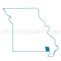
Wappapello Voting District, Butler County, Missouri
About
Outline

Summary
| Unique Area Identifier | 607262 |
| Name | Wappapello Voting District |
| County | Butler County |
| State | Missouri |
| Area (square miles) | 31.45 |
| Land Area (square miles) | 30.88 |
| Water Area (square miles) | 0.56 |
| % of Land Area | 98.22 |
| % of Water Area | 1.78 |
| Latitude of the Internal Point | 36.87849720 |
| Longtitude of the Internal Point | -90.30826880 |
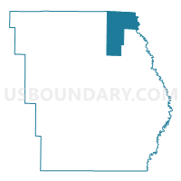
Maps

Graphs
Select a template below for downloading or customizing gragh for Wappapello Voting District, Butler County, Missouri


Neighbors
Neighoring Voting District (by Name) Neighboring Voting District on the Map
- Chaonia Voting District, Wayne County, MO
- Lake Road Voting District, Butler County, MO
- Oak Brier Voting District, Butler County, MO
- Puxico Rural Voting District, Stoddard County, MO
- Rombauer Voting District, Butler County, MO
- Wappapello Voting District, Wayne County, MO
Top 10 Neighboring County Subdivision (by Population) Neighboring County Subdivision on the Map
- Poplar Bluff township, Butler County, MO (25,878)
- Duck Creek township, Stoddard County, MO (3,492)
- Lost Creek township, Wayne County, MO (2,288)
- St. Francois township, Butler County, MO (1,794)
- Black River township, Butler County, MO (1,665)
- Black River township, Wayne County, MO (711)
Top 10 Neighboring Unified School District (by Population) Neighboring Unified School District on the Map
- Poplar Bluff R-I School District, MO (32,169)
- Twin Rivers R-X School District, MO (5,956)
- Greenville R-II School District, MO (5,601)
- Puxico R-VIII School District, MO (4,976)
Top 10 Neighboring State Legislative District Lower Chamber (by Population) Neighboring State Legislative District Lower Chamber on the Map
- State House District 154, MO (36,484)
- State House District 159, MO (35,685)
- State House District 156, MO (34,716)
Top 10 Neighboring State Legislative District Upper Chamber (by Population) Neighboring State Legislative District Upper Chamber on the Map
Top 10 Neighboring 111th Congressional District (by Population) Neighboring 111th Congressional District on the Map
Top 10 Neighboring Census Tract (by Population) Neighboring Census Tract on the Map
- Census Tract 9501, Butler County, MO (5,397)
- Census Tract 4702, Stoddard County, MO (4,573)
- Census Tract 6901, Wayne County, MO (3,603)
- Census Tract 6904, Wayne County, MO (2,422)